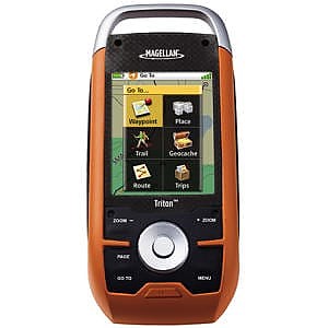
Magellan Triton 1500


![]() Reviewed by
Reviewed by
Jack B
 February 15, 2009
I was looking for a color mapping GPS that I could load topographical maps on. I couldn't stomach the price of a Garmin Colorado or Oregon and to upgrade the other Garmins to get the topo maps cost about the same as a Colorado.
After fruitlessly searching for a used Colorado I stumbled upon the Magellan. I read a little bit about it and it sounded like exactly what I was looking for. It is a color mapping GPS and you can download satellite images and topo maps from National Geographic for $1 a quad , or spend $25 and get a cd of the entire US albeit at a larger scale 1:24,000 for quads or 1:100,000 for cd. Plus they have a program for you computer to let you manage everything on you GPS. I have used it a few times an I love it.
An especially neat feature is the elevation chart for your tracks. It lets you draw a route and then see via chart the elevation changes. Very very cool GPS for about half the price of the top end Garmin.
Price Paid: $200